Birds in BC
|
|---|
|
573 birds have been observed in British Columbia, Canada. Of that, 17 are introduced and 197 are rare or accidental leaving 359 birds. Below is a list of birds photographed by Warren Appleton sorted by biogeoclimatic zone. If you are unsure which zone you are in, refer to the map at the bottom of the page.
|
Search for Birds |
|---|
| Country | Province | Biogeoclimatic Zone | Abbreviation | Type |
|---|
| Canada | British Columbia | Alpine Tundra | AT | View |
| Canada | British Columbia | Spruce - Willow - Birch | SWB | View |
| Canada | British Columbia | Boreal White and Black Spruce | BWBS | View |
| Canada | British Columbia | Sub-Boreal Pine - Spruce | SBPS | View |
| Canada | British Columbia | Sub-Boreal Spruce | SBS | View |
| Canada | British Columbia | Mountain Hemlock | MH | View |
| Canada | British Columbia | Engelmann Spruce - Subalpine Fir | ESSF | View |
| Canada | British Columbia | Montane Spruce | MS | View |
| Canada | British Columbia | Bunchgrass | BG | View |
| Canada | British Columbia | Ponderosa Pine | PP | View |
| Canada | British Columbia | Interior Douglas-Fir | IDF | View |
| Canada | British Columbia | Coastal Douglas-Fir | CDF | View |
| Canada | British Columbia | Interior Cedar - Hemlock | ICH | View |
| Canada | British Columbia | Coastal Western Hemlock | CWH | View |
Protection of Birds in BC |
|---|
Birds in British Columbia, Canada, are protected under the proivncial Wildlife Act and the federal Migratory Bird Convention Act. Federal and provincial parks and ecological researves have been established throughout the province. Development projects that occur on federal sites are subject to environmetnal effects evaluations under the Canadian Environmental Assessment Act 2012, and municipalities require environmental assessments to support development permit applications for private developments. Bald Eagle and Osprey Nests are protected year-round and require a wildlife permit to remove or relocate. Other raptor nests and song bird nests are protected when the nests are active. Development activities that occur between March 1 and August 15 typically require bird sweeps by qualfiied environmental professionals prior to undertaking works that may affect these birds (vegetation removal, building demolishion, etc.). |
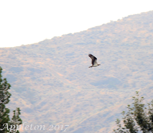 August 2017. Osprey returning to the estuary after fishing for fish in the open waters of Lake Osoyoos in the Okanogan, British Columbia, Canada. The diet of the osprey is 99% live fish; over 80 species of marine and freshwater fish species have been documented as a food source. This osprey was observed swimming in the lake after a few missed attempts. August 2017. Osprey returning to the estuary after fishing for fish in the open waters of Lake Osoyoos in the Okanogan, British Columbia, Canada. The diet of the osprey is 99% live fish; over 80 species of marine and freshwater fish species have been documented as a food source. This osprey was observed swimming in the lake after a few missed attempts. |
|
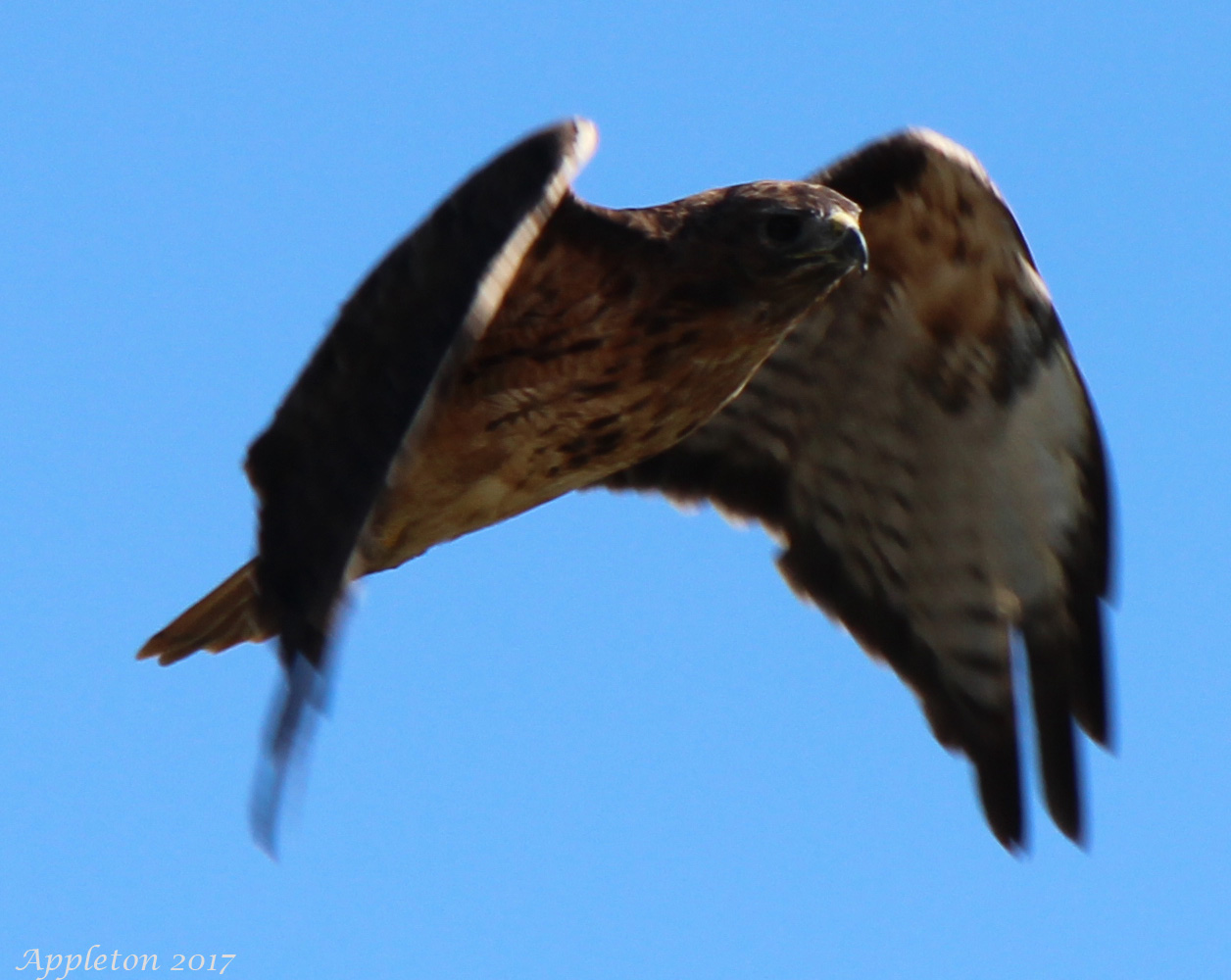 August 2017. Red tailed hawk observed flying over agricultural fields on Westham Island near the George C. Reifel migratory bird sanctuary in Ladner (Delta), BC. The hawk was foraging for small mammals that are present in the fields - they typically feed on voles, mice, wood rats, rabbits, snowshoe hares, jackrabbits, ground squirrels, snakes, other birds (pheasants, bobwhite, starlings, and blackbirds) and carrion up to 5 pounds. August 2017. Red tailed hawk observed flying over agricultural fields on Westham Island near the George C. Reifel migratory bird sanctuary in Ladner (Delta), BC. The hawk was foraging for small mammals that are present in the fields - they typically feed on voles, mice, wood rats, rabbits, snowshoe hares, jackrabbits, ground squirrels, snakes, other birds (pheasants, bobwhite, starlings, and blackbirds) and carrion up to 5 pounds. |
| BC Biogeoclimatic Zone Map (Click to Zoom) |
|---|
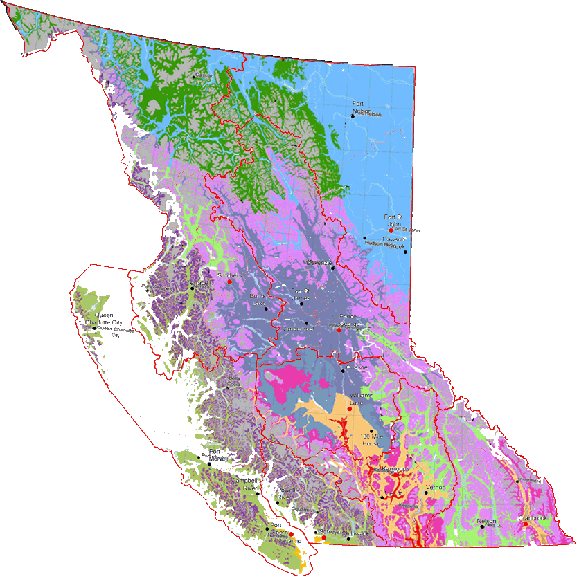 Click on the interactive map to view field maps of the biogeoclimatic subzones. Distribution maps for the various bird species shown were cross-referenced with these maps to determine which biogeoclimatic zones the different bird species occurs.
|
|